OASES OF THE WORLD
A. INTRODUCTION
B. DAKHLA OASIS, EGYPT
DAKHLA OASIS: IMAGE 1
DAKHLA OASIS: IMAGE 2
DAKHLA OASIS: IMAGE 3
DAKHLA OASIS: IMAGE 4
C. SIWA OASIS, EGYPT
SIWA OASIS: IMAGE 1
SIWA OASIS: IMAGE 2
SIWA OASIS: IMAGE 3
SIWA OASIS: IMAGE 4
D. GHARDAIA OASIS, ALGERIA
GHARDAIA OASIS: IMAGE 1
GHARDAIA OASIS: IMAGE 2
GHARDAIA OASIS: IMAGE 3
GHARDAIA OASIS: IMAGE 4
E. GUERRARA OASIS, ALGERIA
GUERRARA OASIS: IMAGE 1
GUERRARA OASIS: IMAGE 2
GUERRARA OASIS: IMAGE 3
GUERRARA OASIS: IMAGE 4
F. KUFRA OASIS, LYBIA
KUFRA OASIS: IMAGE 1
KUFRA OASIS: IMAGE 2
KUFRA OASIS: IMAGE 3
KUFRA OASIS: IMAGE 4
G. SAN PEDRO DE ATACAMA, CHILE
SAN PEDRO DE ATACAMA: IMAGE 1
SAN PEDRO DE ATACAMA: IMAGE 2
SAN PEDRO DE ATACAMA: IMAGE 3
SAN PEDRO DE ATACAMA: IMAGE 4
H. EN GEDI OASIS, ISRAEL
EN GEDI OASIS: IMAGE 1
EN GEDI OASIS: IMAGE 2
EN GEDI OASIS: IMAGE 3
EN GEDI OASIS: IMAGE 4
I. TURPAN OASIS, CHINA
TURPAN OASIS: IMAGE 1
TURPAN OASIS: IMAGE 2
TURPAN OASIS: IMAGE 3
TURPAN OASIS: IMAGE 4
J. YZAD OASIS, IRAN
YZAD OASIS: IMAGE 1
YZAD OASIS: IMAGE 2
YZAD OASIS: IMAGE 3
YZAD OASIS: IMAGE 4
K. TAYMA OASIS, SAUDI ARABIA
TAYMA OASIS: IMAGE 1
TAYMA OASIS: IMAGE 2
TAYMA OASIS: IMAGE 3
TAYMA OASIS: IMAGE 4
A. INTRODUCTION
Oasis is a Greek word and means “inhabited place”.
An oasis is an area covered with vegetation in the desert. Because of different water sources oases can be classified into the following groups:
- Groundwater oasis:
The water is brought to the surface with a pump or a well
- River water oasis:
A river supplies the oasis with water from rain-laden areas.
- Spring water oasis:
A spring water oasis is located at places where groundwater table reaches the earth’s surface. It is the most common type of oasis.
- Oasis with an artesian well:
The groundwater rises to the surface because of overpressure.
Oases were once very important for the caravan trade and agriculture but they lost their importance in times of modern transportation techniques. One of the most important products was once the date. But some of the North African oases had a structural change and could intensify their agriculture because of the use of deeper laying water resources.
One of the biggest problems of oases is still the salinisation. It occurs whenever water evaporates because the soluble salts remain in the soil. The salinisation in some oases is extended so far that agriculture is not possible anymore.
B. DAKHLA OASIS, EGYPT
Dakhla is one of the five western oases in the Libyan Desert in Egypt. The 14 villages are situated in a swale surrounded by rocks and are home to 70.000 people. The oasis has 30.000 ha cultivable land where basically date palms, citrus fruits and mulberrys are grown.
DAKHLA OASIS: IMAGE 1
NORTH EAST VIEW

This image shows an overview of the Dhakla Oasis facing north east.
Co-ordinates: 28°59'18.21"E, 25°30'45.48"N, width of image: 79,81km
DAKHLA OASIS: IMAGE 2
NORTH WEST VIEW

This image shows the water sources of the Dakhla Oasis facing north west.
Co-ordinates: 28°59'18.21"E, 25°30'45.48"N, width of image: 2,35km
DAKHLA OASIS: IMAGE 3
NORTH WEST

This image shows fields and irrigation system in the Dakhla Oasis facing north west.
Co-ordinates: 28°59'18.21"E, 25°30'45.48"N, width of image: 250m.
DAKHLA OASIS: IMAGE 4
NORTH VIEW

This image shows huge salinsation of fields in the Dakhla Oasis facing north.
Co-ordinates: 28°59'18.21"E, 25°30'45.48"N, width of image: 720m.
C. SIWA OASIS, EGYPT
Siwa is also one of the five western oases in the Libyan Desert in Egypt. This oasis is 80km long, 2- 20km wide and located 18m under the sea level. In several villages live about 23.000 people. Most of them are farmers that cultivate date palms and olive trees.
SIWA OASIS: IMAGE 1
NORTH VIEW

This image shows an overview of the Siwa Oasis facing north.
Co-ordinates: 25°32'3.60"E, 29°13'21.74"N, width of image:39,89km.
SIWA OASIS: IMAGE 2
NORTH VIEW

This image shows a village in the Siwa Oasis facing north.
Co-ordinates: 25°32'3.60"E, 29°13'21.74"N, width of image: 3,97km.
SIWA OASIS: IMAGE 3
NORTH VIEW

This image shows fields and the irrigation facing the north.
Co-ordinates: 25°32'3.60"E, 29°13'21.74"N, width of image: 270m.
SIWA OASIS: IMAGE 4
EAST VIEW

This image shows salinisation and huge water channels facing east.
Co-ordinates: 25°32'3.60"E, 29°13'21.74"N, width of image: 2,15km.
D. GHARDAIA OASIS, ALGERIA
Ghardaia (Algeria) is located in a valley called M`zab in the nothern part of the Sahara. The wadi Mzab supplies all oases in the valley with water after heavy rainfalls. In several smaller towns and villages live 82500 people. Most of them are farmers and cultivate date palms. Ghardaia has its own airport and exports not only dats but also petroleum and natural gas.
GHARDAIA OASIS: IMAGE 1
EAST VIEW

Overview of the Ghardaia Oasis in Algeria facing west.
Co-ordinates: 3°40'47.07"E, 32°29'19.07"N, width of image: 11,56km.
GHARDAIA OASIS: IMAGE 2
NORTH WEST VIEW

Village in the Ghardaia Oasis. View: north west.
Co-ordinates: 3°40'47.07"E, 32°29'19.07"N, width of image: 760m.
GHARDAIA OASIS: IMAGE 3
SOUTH EAST VIEW

This Image shows some fields in the Ghardaia Oasis facing east.
Co-ordinates: 3°40'47.07"E, 32°29'19.07"N, width of image: 500m
GHARDAIA OASIS: IMAGE 4
WEST VIEW

This image shows a riverbed in the Ghardaia Oasis facing west.
Co-ordinates: 3°40'47.07"E, 32°29'19.07"N, width of image: 2,65km
E. GUERRARA OASIS, ALGERIA
Guerrara is also an Oasis in the M`zab valley. (no more information available)
GUERRARA OASIS: IMAGE 1
NORTH VIEW

Overview of the Guerrara Oasis in Algeria facing north.
Co-ordinates: 4°40'7.51"E, 32°46'41.86"N, width of image:12,11km.
GUERRARA OASIS: IMAGE 2
WEST VIEW

This image shows the water sources of the Guerrara Oasis facing west.
Co-ordinates: 4°40'7.51"E, 32°46'41.86"N, width of image: 4,14km.
GUERRARA OASIS: IMAGE 3
NORTH VIEW

Big fields in the Guerrara Oasis facing north.
Co-ordinates: 4°40'7.51"E, 32°46'41.86"N, width of image: 3,59km
GUERRARA OASIS: IMAGE 4
EAST VIEW

in the Guerrara Oasis facing east.
Co-ordinates: 4°40'7.51"E, 32°46'41.86"N, width of image: 4,23km
F. KUFRA OASIS, LIBYA
The Kufra Oasis is located in the south east of Libya. In the 1970ies several big irrigation projects made intensive agriculrure possible. For the last 30 years the oasis was irrigated with fossile ground water. Today the ground water level is about 60m lowered. There are no data about how long the Kufra will be supplied with water. But scientist expect that this Oasis will dry out in only a few years
KUFRA OASIS: IMAGE 1
NORTH VIEW

Overview of the Kufra Oasis in Libya facing north.
Co-ordinates: 23°19'10.79"E, 24°8'49.35"N, width of image: 49,29km
KUFRA OASIS: IMAGE 2
SOUTH VIEW

This image shows the big round fields and a part of the irrigation system facing south.
Co-ordinates: 23°19'10.79"E, 24°8'49.35"N, width of image: 4,15km.
KUFRA OASIS: IMAGE 3
NORTH VIEW

This image shows big fields in the Kufra Oasis with irrigation system facing north.
Co-ordinates: 23°19'10.79"E, 24°8'49.35"N, width of image: 4,71km.
KUFRA OASIS: IMAGE 4
NORTH VIEW
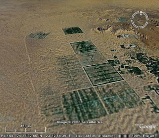
Square fields in the Kufra Oasis facing north.
Co-ordinates: 23°19'10.79"E, 24°8'49.35"N, width of image: 4,63km.
A. INTRODUCTION
B. DAKHLA OASIS, EGYPT
DAKHLA OASIS: IMAGE 1
DAKHLA OASIS: IMAGE 2
DAKHLA OASIS: IMAGE 3
DAKHLA OASIS: IMAGE 4
C. SIWA OASIS, EGYPT
SIWA OASIS: IMAGE 1
SIWA OASIS: IMAGE 2
SIWA OASIS: IMAGE 3
SIWA OASIS: IMAGE 4
D. GHARDAIA OASIS, ALGERIA
GHARDAIA OASIS: IMAGE 1
GHARDAIA OASIS: IMAGE 2
GHARDAIA OASIS: IMAGE 3
GHARDAIA OASIS: IMAGE 4
E. GUERRARA OASIS, ALGERIA
GUERRARA OASIS: IMAGE 1
GUERRARA OASIS: IMAGE 2
GUERRARA OASIS: IMAGE 3
GUERRARA OASIS: IMAGE 4
F. KUFRA OASIS, LYBIA
KUFRA OASIS: IMAGE 1
KUFRA OASIS: IMAGE 2
KUFRA OASIS: IMAGE 3
KUFRA OASIS: IMAGE 4
G. SAN PEDRO DE ATACAMA, CHILE
SAN PEDRO DE ATACAMA: IMAGE 1
SAN PEDRO DE ATACAMA: IMAGE 2
SAN PEDRO DE ATACAMA: IMAGE 3
SAN PEDRO DE ATACAMA: IMAGE 4
H. EN GEDI OASIS, ISRAEL
EN GEDI OASIS: IMAGE 1
EN GEDI OASIS: IMAGE 2
EN GEDI OASIS: IMAGE 3
EN GEDI OASIS: IMAGE 4
I. TURPAN OASIS, CHINA
TURPAN OASIS: IMAGE 1
TURPAN OASIS: IMAGE 2
TURPAN OASIS: IMAGE 3
TURPAN OASIS: IMAGE 4
J. YZAD OASIS, IRAN
YZAD OASIS: IMAGE 1
YZAD OASIS: IMAGE 2
YZAD OASIS: IMAGE 3
YZAD OASIS: IMAGE 4
K. TAYMA OASIS, SAUDI ARABIA
TAYMA OASIS: IMAGE 1
TAYMA OASIS: IMAGE 2
TAYMA OASIS: IMAGE 3
TAYMA OASIS: IMAGE 4
A. INTRODUCTION
Oasis is a Greek word and means “inhabited place”.
An oasis is an area covered with vegetation in the desert. Because of different water sources oases can be classified into the following groups:
- Groundwater oasis:
The water is brought to the surface with a pump or a well
- River water oasis:
A river supplies the oasis with water from rain-laden areas.
- Spring water oasis:
A spring water oasis is located at places where groundwater table reaches the earth’s surface. It is the most common type of oasis.
- Oasis with an artesian well:
The groundwater rises to the surface because of overpressure.
Oases were once very important for the caravan trade and agriculture but they lost their importance in times of modern transportation techniques. One of the most important products was once the date. But some of the North African oases had a structural change and could intensify their agriculture because of the use of deeper laying water resources.
One of the biggest problems of oases is still the salinisation. It occurs whenever water evaporates because the soluble salts remain in the soil. The salinisation in some oases is extended so far that agriculture is not possible anymore.
B. DAKHLA OASIS, EGYPT
Dakhla is one of the five western oases in the Libyan Desert in Egypt. The 14 villages are situated in a swale surrounded by rocks and are home to 70.000 people. The oasis has 30.000 ha cultivable land where basically date palms, citrus fruits and mulberrys are grown.
DAKHLA OASIS: IMAGE 1
NORTH EAST VIEW

This image shows an overview of the Dhakla Oasis facing north east.
Co-ordinates: 28°59'18.21"E, 25°30'45.48"N, width of image: 79,81km
DAKHLA OASIS: IMAGE 2
NORTH WEST VIEW

This image shows the water sources of the Dakhla Oasis facing north west.
Co-ordinates: 28°59'18.21"E, 25°30'45.48"N, width of image: 2,35km
DAKHLA OASIS: IMAGE 3
NORTH WEST

This image shows fields and irrigation system in the Dakhla Oasis facing north west.
Co-ordinates: 28°59'18.21"E, 25°30'45.48"N, width of image: 250m.
DAKHLA OASIS: IMAGE 4
NORTH VIEW

This image shows huge salinsation of fields in the Dakhla Oasis facing north.
Co-ordinates: 28°59'18.21"E, 25°30'45.48"N, width of image: 720m.
C. SIWA OASIS, EGYPT
Siwa is also one of the five western oases in the Libyan Desert in Egypt. This oasis is 80km long, 2- 20km wide and located 18m under the sea level. In several villages live about 23.000 people. Most of them are farmers that cultivate date palms and olive trees.
SIWA OASIS: IMAGE 1
NORTH VIEW

This image shows an overview of the Siwa Oasis facing north.
Co-ordinates: 25°32'3.60"E, 29°13'21.74"N, width of image:39,89km.
SIWA OASIS: IMAGE 2
NORTH VIEW

This image shows a village in the Siwa Oasis facing north.
Co-ordinates: 25°32'3.60"E, 29°13'21.74"N, width of image: 3,97km.
SIWA OASIS: IMAGE 3
NORTH VIEW

This image shows fields and the irrigation facing the north.
Co-ordinates: 25°32'3.60"E, 29°13'21.74"N, width of image: 270m.
SIWA OASIS: IMAGE 4
EAST VIEW

This image shows salinisation and huge water channels facing east.
Co-ordinates: 25°32'3.60"E, 29°13'21.74"N, width of image: 2,15km.
D. GHARDAIA OASIS, ALGERIA
Ghardaia (Algeria) is located in a valley called M`zab in the nothern part of the Sahara. The wadi Mzab supplies all oases in the valley with water after heavy rainfalls. In several smaller towns and villages live 82500 people. Most of them are farmers and cultivate date palms. Ghardaia has its own airport and exports not only dats but also petroleum and natural gas.
GHARDAIA OASIS: IMAGE 1
EAST VIEW

Overview of the Ghardaia Oasis in Algeria facing west.
Co-ordinates: 3°40'47.07"E, 32°29'19.07"N, width of image: 11,56km.
GHARDAIA OASIS: IMAGE 2
NORTH WEST VIEW

Village in the Ghardaia Oasis. View: north west.
Co-ordinates: 3°40'47.07"E, 32°29'19.07"N, width of image: 760m.
GHARDAIA OASIS: IMAGE 3
SOUTH EAST VIEW

This Image shows some fields in the Ghardaia Oasis facing east.
Co-ordinates: 3°40'47.07"E, 32°29'19.07"N, width of image: 500m
GHARDAIA OASIS: IMAGE 4
WEST VIEW

This image shows a riverbed in the Ghardaia Oasis facing west.
Co-ordinates: 3°40'47.07"E, 32°29'19.07"N, width of image: 2,65km
E. GUERRARA OASIS, ALGERIA
Guerrara is also an Oasis in the M`zab valley. (no more information available)
GUERRARA OASIS: IMAGE 1
NORTH VIEW

Overview of the Guerrara Oasis in Algeria facing north.
Co-ordinates: 4°40'7.51"E, 32°46'41.86"N, width of image:12,11km.
GUERRARA OASIS: IMAGE 2
WEST VIEW

This image shows the water sources of the Guerrara Oasis facing west.
Co-ordinates: 4°40'7.51"E, 32°46'41.86"N, width of image: 4,14km.
GUERRARA OASIS: IMAGE 3
NORTH VIEW

Big fields in the Guerrara Oasis facing north.
Co-ordinates: 4°40'7.51"E, 32°46'41.86"N, width of image: 3,59km
GUERRARA OASIS: IMAGE 4
EAST VIEW

in the Guerrara Oasis facing east.
Co-ordinates: 4°40'7.51"E, 32°46'41.86"N, width of image: 4,23km
F. KUFRA OASIS, LIBYA
The Kufra Oasis is located in the south east of Libya. In the 1970ies several big irrigation projects made intensive agriculrure possible. For the last 30 years the oasis was irrigated with fossile ground water. Today the ground water level is about 60m lowered. There are no data about how long the Kufra will be supplied with water. But scientist expect that this Oasis will dry out in only a few years
KUFRA OASIS: IMAGE 1
NORTH VIEW

Overview of the Kufra Oasis in Libya facing north.
Co-ordinates: 23°19'10.79"E, 24°8'49.35"N, width of image: 49,29km
KUFRA OASIS: IMAGE 2
SOUTH VIEW

This image shows the big round fields and a part of the irrigation system facing south.
Co-ordinates: 23°19'10.79"E, 24°8'49.35"N, width of image: 4,15km.
KUFRA OASIS: IMAGE 3
NORTH VIEW

This image shows big fields in the Kufra Oasis with irrigation system facing north.
Co-ordinates: 23°19'10.79"E, 24°8'49.35"N, width of image: 4,71km.
KUFRA OASIS: IMAGE 4
NORTH VIEW

Square fields in the Kufra Oasis facing north.
Co-ordinates: 23°19'10.79"E, 24°8'49.35"N, width of image: 4,63km.
posted by annegreat at
3/22/2007 09:14:00 AM
![]()
![]()

0 Comments:
Post a Comment
<< Home